SELECTED GRADUATE SCHOOL PROJECTS
Click the images to view each project

MASTER'S THESIS:
SLAUGHTER BEACH SALT POND
AND WATER CHANNEL
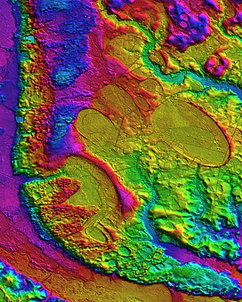
DYNAMICISM
Between 1000-5000 salt marsh ponds ranging in size from 0.03 m2 to 73,477 m2 have been documented at ~ 4 km2 salt marsh platform near Slaughter Beach, Delaware. The salt marsh of the study area is vegetated by Sp. Alterniflora, Sp. Patens, and Distichlis Spicata species, dissected by natural tidal creeks, man-made channels and ditching created as part of the Army Corps of Engineers’ mosquito efforts in the 1930’s. Through the analysis of drone imagery we documented that the salt ponds decreased in size and count from November 2017 to February 2018 but showed a steady increase in size and count from February to September 2018. The size and count of the salt ponds between fall of 2017 and summer of 2018 appear to correlate with tidal fluctuations in the southern Delaware Bay region.

STUDENT PROJECT: CHESTER COUNTY TROUT STREAMS AND THE TOXIC RELEASE INVENTORY (TRI)
Chester County is home to several well-stocked trout fishing streams. Through spatial analysis and data exploration, this report will seek to identify any stocked streams which have been exposed to hazardous chemical releases.
This analysis assumes that any stream that lies within the same watershed that contains a TRI facility is at risk from exposure to hazardous water released by those facilities. It does not take into account the type or quantity of material released, and therefore is not an accurate method to quantify the type of risk that may be associated with a release. However, out of fifteen trout-stocked streams, there are eleven which have had no recorded TRI water release within their watersheds.

STUDENT PROJECT: GEOMETRICS
AND THE
EXPLORATION OF DATA
The materials that were taught and the work that I did this semester greatly broadened my understanding of exploratory data analysis. It is my hope that by the creation of this portfolio that the knowledge unlocked here will be retained for my future use.
STUDENT PROJECT: CAROLINA BAYS: A MODERN
GEOLOGICAL MYSTERY
Carolina Bays are most likely eolian and lacustrine in origin
Some bays have datable sand rims that may correlate with Dansgaard–Oeschger events
Prevailing winds are the primary driver
Prevailing winds have changed little (south of 40°N) during Pleistocene and Holocene